Singapore centralises data sharing for underground infrastructure with new portal
The Singapore Land Authority’s Utility Survey Submission Portal (USSP) aims to standardise underground utility data and help the country avoid costly infrastructure conflicts before construction begins.
-1781513556916.jpg)
Minister for National Development, Chee Hong Tat, announced the development of SLA's Utility Survey Submission Portal (USSP) portal at the World Cities Summit (WCS) 2026 on June 14. Image: WCS
Singapore is now centralising how it tracks the use of its underground space, with the Singapore Land Authority (SLA) currently piloting the Utility Survey Submission Portal (USSP).
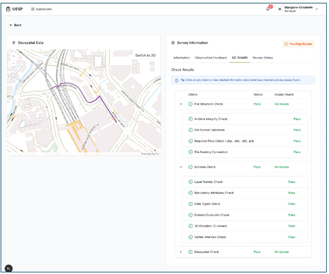
USSP serves as a one-stop portal for project parties to submit surveyed plans for underground utilities.
SLA aims to consolidate and standardise data collection and management, automate quality checks and seamlessly integrate data across different agencies for the country's underground infrastructure.
Since April, selected government agencies have been submitting their utility data via the portal, with plans to open it to private sector partners on a voluntary basis from late 2026, before scaling across all utility sectors from 2027.
The development of the portal was announced at the World Cities Summit (WCS) in Singapore on June 14.
“Beneath our city lies a complex and dense network of utility infrastructure, which requires careful planning and coordination,” said Minister for National Development, Chee Hong Tat, in the opening address.
When utility owners manage their assets separately and records are scattered across systems, conflicts surface too late during mid-construction and fixing these conflicts could result in higher costs, duplicated work and longer timelines, he highlighted.
The minister underlined the portal’s importance in enabling a reliable, up-to-date shared picture of what lies underground.
Digital platform supported by governance framework
Alongside the portal's rollout, SLA is working with industry stakeholders to develop a governance framework.
The framework would set the protocols for how underground utility data is collected and shared through the portal.
According to the official release, the portal would automate validation processes to ensure that all utility submissions have consistent data standards, visualise data through 3D mapping to support decision-making for infrastructure projects.
On stakeholder engagement, earlier this year, SLA gathered experts from Europe and Asia Pacific to discuss the challenges in managing underground asset registers (UARs) in the respective countries.
UARs refer to online maps that unify utility data from various organisations into a single view.
The topics discussed included how to secure meaningful stakeholder engagement, maintain data integrity and quality, and navigate shared responsibility in data governance.
SLA expects to publish a playbook of global best practices and key insights around UARs in July this year.
Multiple agencies involved to manage underground space
The portal complements existing efforts by the Urban Development Authority (URA) since 2024, through the Major Infrastructure (Network) Workflow and the Infrastructure Network Planning and Alignment Clearance (INPAC).
The enhanced workflow improves the advanced planning across major infrastructure projects, by appointing lead agencies to identify and resolve potential conflicts of multiple infrastructure projects along the same route.
INPAC, on the other hand, is the online platform underpinning that workflow, enables multi-agency consultations and whole-of-government map sharing.
The minister shared that to date, the initiative has coordinated about 272 kilometres of utility corridors and saved about S$300 million from having to re-route existing utilities halfway through construction.
The workflow has also pushed project teams to innovate.
By requiring comprehensive site investigations before any work begins, teams would adopt non-invasive detection technologies like electromagnetic locators to see underground utility networks from above ground.
This cuts the need for exploratory digging and reducing disruption to road users.
“We intend to scale up the use of these technologies,” said the Minister.
Singapore’s overall infrastructure development is guided by the National Infrastructure Plan (NIP), which serves as the foundation for identifying and coordinating major projects over a 15-year horizon.
To align with the broader plan, government agencies and private sector partners submit their plans to URA for review and alignment.