-1783304403050.jpg)
AI and unified data reimagining local land governance in the Philippines
By Yen Ocampo
Department of Environment and Natural Resources (DENR)’s Secretary Raphael Lotilla shares how multi-agency collaboration coupled with a data-driven approach have transformed land use planning in the country.
-1771909212882.jpg)
Led by Department of Environment and Natural Resources (DENR)'s Secretary Raphael Lotilla, the AI-Powered Knowledge Hub was unveiled late last year, marking a significant milestone in DENR-ERDB’s ongoing digital transformation efforts. Image: DENR
The Philippines has rolled out a unified platform, PlanSmart for Sustainable Human Settlements, that combines hazard data, land use standards and environmental datasets from multiple government agencies.
Launched by the country’s Department of Environment and Natural Resources (DENR), the platform also incorporates tools to support local governments in using the data to develop smart, safe, and sustainable communities.
Speaking to GovInsider, DENR’s Secretary Raphael Lotilla says that governance works best through multi-agency collaboration coupled with a data-driven approach to land use planning.
Multi-agency collaboration enabling a unified platform
The platform combines data from the Department of Science and Technology (DOST), Department of Human Settlements and Urban Development (DHSUD), and DENR, says Lotilla.
Specific examples of data being integrated into the platform include flood-prone areas, forest cover, biodiversity hotspots, land use patterns, hazard maps, and demographic data.
Lotilla notes that local government units (LGUs) can use the platform to identify at-risk areas, plan infrastructure projects, and prioritise interventions to strengthen climate resilience.
Rather than having LGUs approach each agency separately, national agencies can coordinate to deliver their services together as a single, unified platform, he says.
LGUs can also tap on a variety of tools on the platform to overlay different datasets to simulate outcomes of proposed development plans.
This capability transforms raw data into actionable insights, enabling evidence-based planning.
For example, the platform has a hazard mapping tool that allows LGUs to visualise flood, storm surge, and landslide risks within their jurisdictions, he adds.
This ensures that communities remain safe from environmental hazards and are also positioned to thrive sustainably. By promoting data-driven planning, PlanSmart reduces guesswork and enhances transparency and efficiency in urban and rural development.
There are also land use simulation tools that enable planners to see how different development scenarios impact ecosystems, water resources, and population distribution. These modules help LGUs make informed decisions that balance growth with environmental protection.
Additionally, PlanSmart allows planners to create comprehensive development plans with geospatial analysis and risk assessments.
By offering scenario analysis and predictive modelling, LGUs can proactively implement mitigation strategies, such as relocating high-risk settlements or reinforcing infrastructure.
However, says Lotilla, there are challenges such as digital infrastructure disparities, data standardisation, and integration.
LGUs in remote areas may lack high-speed internet, adequate computing resources, or trained personnel to use these digital platforms effectively. This can hinder widespread adoption and limit the platforms’ potential impact, he adds.
Another challenge is that environmental and spatial datasets come from multiple agencies with varying formats, resolution, and quality.
Ensuring that data is accurate, consistent, and interoperable is critical for reliable analysis, Lotilla notes. Additionally, user training, cybersecurity, and platform maintenance are essential to sustain long-term usability and stakeholder confidence, he explains.
AI makes environmental information more accessible
DENR’s Ecosystems Research and Development Bureau (ERDB) has also launched an AI‑Powered Knowledge Hub to make environmental research more accessible to non-technical users.
Lotilla says the hub is a groundbreaking tool for managing and accessing environmental research, noting that it reflects ERDB’s legacy of combining science, nature, and practical action.
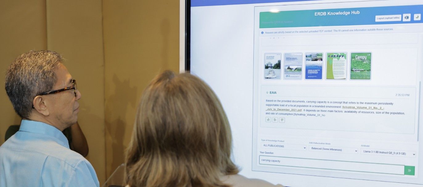
The system enables users to search and interact with publications using natural language, making information more accessible for researchers, policymakers, and the public.
He adds that the platform not only safeguards ERDB’s vast scientific knowledge but also lays the groundwork for solutions that promote a sustainable future.
The AI-Powered Knowledge Hub transforms access to environmental research by providing a centralised, searchable platform where technical, scientific, and semi-technical publications are readily available.
By interpreting natural language queries, categorising documents, identifying trends, and cross-referencing related topics, the platform delivers contextually relevant information quickly, reducing the need to manually sift through archives.
The AI-driven features, including intelligent recommendations, allow users to explore connections across studies, apply research directly to policy, and foster evidence-based decision-making.
This creates a dynamic knowledge ecosystem that strengthens the link between scientific research and practical environmental management while encouraging innovative, interdisciplinary solutions, Lotilla says.