-1783304403050.jpg)
Shaping APAC’s regional strategy and deterrence with AI-powered GEOINT
By Planet
AI-powered GEOINT is reshaping regional geospatial strategy and deterrence across APAC. In this article, Planet discussed how near-daily satellite data and analytics support deterrence, ISR, and maritime domain awareness.
-1770772265828.jpg)
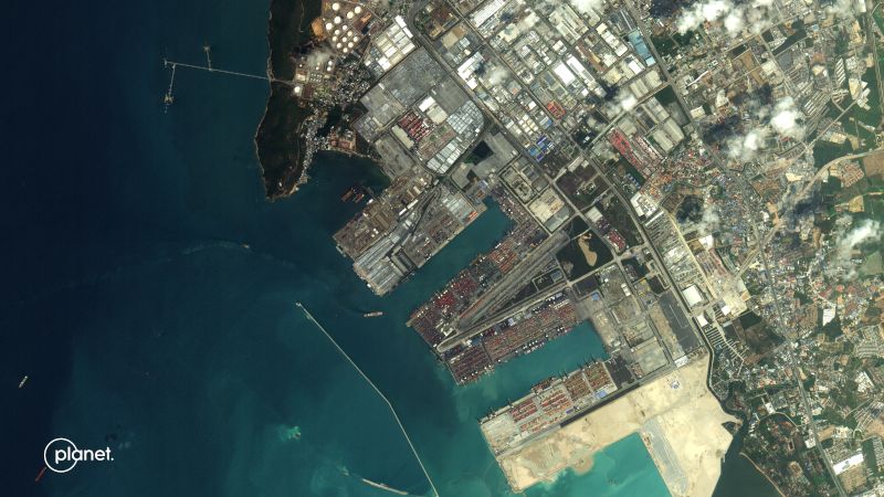
SkySat® Tip and Cue series for Malacca Strait and ship-to-ship transfer in Malaysia, captured on January 16, 2026. Image: Planet Labs PBC
2025 marked a decisive shift for Planet and their Asia-Pacific partners and customers.
Now more than ever, Planet data is being used not only to gain insight after significant events occur — but to help prevent them.
“Across Asia-Pacific, we are seeing a clear move away from reactive intelligence,” said Kian Kang, Head of Sales, APAC at Planet.
“Governments and partners are no longer asking for imagery after an event. They want insight early enough to prevent escalation.”
Let’s take a look at forces shaping commercial geointelligence (GEOINT) in Asia-Pacific and how recent milestones at Planet signal a new era for defense, intelligence, civil, and commercial customers in a region where persistence, speed, and trust enable prevention rather than reaction.
Commercial GEOINT adoption in APAC
Across Asia-Pacific, adoption of commercial geospatial intelligence is accelerating rapidly in North and South Asia, particularly in Japan, the Republic of Korea, Taiwan, and India.
It is shifting from a supporting tool to a core strategic pillar driven by several factors, including:
- Heightened geopolitical tension across the Indo-Pacific
- Increased defense and intelligence, surveillance, and reconnaissance (ISR) budgets
- Lessons from recent conflicts, which highlighted the value of commercial imagery for speed, resilience, and transparency
- A growing openness to commercial solutions to support existing ISR capabilities without long development cycles
- Climate driven natural disasters that will increasingly drive humanitarian crises, supply-chain disruption, and internal displacement
For many governments, commercial GEOINT is a strategic enabler of deterrence and preparedness.
“We’re seeing a clear shift toward commercial GEOINT as a core component of national capability,” Kang said. “Governments want to build integrated ISR faster, and commercial providers help close that gap.”
Historically, the demand for commercial geospatial intelligence in Asia-Pacific focused on low-frequency tasking. Imagery was used to map terrain, catalogue static infrastructure, and support long-term planning. Value came from resolution and accuracy, not revisit rate.
That model no longer matches the modern threat environment.
Defense and intelligence agencies now face fast-moving, ambiguous challenges: gray-zone operations, maritime pressure, rapid infrastructure expansion, force posturing, and disaster-linked instability.
The core intelligence question has shifted from “What is there?” to “What is changing, and what looks abnormal?”
As a result, demand is increasingly centered on:
- Persistent monitoring of areas of interest (AOI) as seen on Planet partner, Tony Blair Institute for Global Change’s hazard mapping technology using PlanetScope® and SkySat imagery
- Time-series analysis instead of single images
- Automated change and anomaly detection that establish patterns of life to flag deviations and power early warning at scale
- AI-powered geospatial insights to infuse speed into customer workflows
GEOINT is transitioning from analytical to operational. It is no longer just static image reports but shifting towards operationalising commercial geospatial intelligence.
Recognising this changing landscape, Planet has scaled our regionally embedded team with two new additions:
- Brian Lee, an Australian professional of Korean background serving as Sr. Manager, Pre-Sales and Services, APAC
- Jayang Yang, an intelligence and defense professional joining as Industry Account Executive for defense and intelligence
Building the foundation for prevention
Planet recognises the increasing need for always-on monitoring to help identify and verify threats, early. Three key milestones in 2025 are helping to define this transition.
Pelican™ and Owl™: Enhanced imaging capabilities
In 2025, Planet successfully launched five Pelican satellites, significantly advancing the imaging quality, spectral depth, revisit rates, and on-orbit AI processing of our tasking fleet.
These upgrades translate into faster access to actionable commercial intelligence, as onboard processing reduces latency, enabling near-real-time change detection across maritime corridors, borders, and infrastructure nodes.
“Pelican changes the conversation from ‘what happened’ to ‘what is changing right now,’” Kian explained. “That shift is critical for defense, disaster response, and environmental monitoring across Asia-Pacific.”
And they also announced plans for Owl, their next-generation, AI-enabled monitoring fleet targeting near-daily 1-meter resolution imagery. “Owl is about persistence by design.
For customers dealing with gray-zone activity, maritime pressure, or climate-linked instability, daily awareness is no longer a luxury — it’s a requirement,” said Kian.
These advances in their imaging capabilities will bolster the shift to a proactive risk detection and validation at a global scale.
Planet’s Maritime Domain Awareness solution: Increasing situational awareness
Persistent commercial satellite data plays a critical role in national security priorities across APAC, from border surveillance to dark shipping detection and activity monitoring.
Unlike airborne or terrestrial systems, satellites provide a vantage point that is free from geographic, diplomatic, or airspace restrictions. Near-daily coverage enables agencies to establish a baseline pattern of life, making anomalies visible before they escalate.
“Space-based monitoring removes many of the geographic and political limitations that other systems face,” Kian said. “That persistence is what allows patterns of life to emerge.”
Examples include:
- Vessels operating without AIS signals
- Sudden changes in port activity or logistics flows
- Shifts in maritime or air traffic patterns
The recently launched Planet Maritime Domain Awareness (MDA) solution offers:
- Comprehensive near-daily 3.7 m open water coverage that provides regular monitoring over your AOI or target area of interest (TAI).
- AI/ML-driven vessel detection analytics that can identify vessels longer than 25 m, providing essential details like classification (including cargo, tanker, passenger, aircraft carrier, and military), location coordinates, estimated vessel length and heading, exact date and time of imagery capture, and a confidence score for each detection.
- Advanced monitoring capabilities such as spoofing detection and vessel path prediction.
Explore how Planet can strengthen maritime domain awareness in your territory in their new defense and intelligence solutions brief.
A landmark APAC partnership: Dedicated satellite capacity
The $230 million commercial agreement for Pelican satellites with Planet’s Asia-Pacific partner SKY Perfect JSAT leverages their core strength of building, launching, and operating large fleets of Earth imaging satellites.
It also reflects a strong regional confidence in both Pelican’s performance and Planet’s capabilities.
“Japanese partners are uncompromising when it comes to performance.
"Their early commitment underscores a growing regional willingness to adopt commercial space solutions as core national capability, not supplementary infrastructure,” Kian added.
Will Marshall, Planet’s CEO and Co-founder, remarked, “These types of partnerships are a win-win: our partners gain critical satellite capabilities and priority access to leading-edge technology, while they help Planet accelerate key space programs and create synergistic benefits for all our customers.
We are strategically pursuing a select number of similar opportunities, spanning our Pelican, Tanager and SuperDove satellites across the defense and intelligence, civil government, and commercial sectors.”
This agreement has since become a model for the rest of Asia-Pacific and international partners who are looking into commercial space solutions in the near future.
The 2026 APAC strategic outlook
The Asia-Pacific landscape is currently defined by a compelling contrast: unprecedented economic opportunity set against a backdrop of increasing geopolitical and regulatory complexity.
For regional leaders, success in 2026 depends on navigating customer requirements with precision—turning the challenges of local compliance into a strategic advantage for national security and sustainable growth.
Licensing, data residency, and export controls remain key considerations to support product enhancements and customer delivery.
Planet will continue close monitoring of regulatory shifts across the region, working proactively to ensure compliance while maintaining operational continuity for customers.
Planet’s strategy for 2026 centers on maintaining a globally consistent platform while enabling localized deployment, governance, and partnership models. This balance is essential in a region as diverse as Asia-Pacific.
“Success in this region requires flexibility. You have to balance global scale with deeply local needs,” Kian added.
Looking beyond security and compliance, they see their solutions enabling long-term initiatives and policies to advance sustainable development and climate resilience across Asia-Pacific, and support broader regional stability and increasingly intersect with core national security priorities.
The shift toward prevention is unmistakable. Persistent monitoring, advanced analytics, and trusted partnerships are redefining how governments and organizations understand risk and act before it escalates.
Planet’s 2025 milestones of launching new and improved constellations and regional partnerships reflect a clear commitment to a future where insight arrives early enough to make a difference.
Discover new ways to enhance maritime domain awareness and operational readiness in your territory for 2026. Register to join Planet’s webinar, APAC GeoGov Insights Episode 1: Maritime Decision Advantage: Persistent AI Monitoring for the New Normal on February 18, 2026, 11:00 AM SGT.